What El Niño 2026-27 is likely to do to Brazil's rainy season
Quentin Franque · 2026-10-30 · 6 minutes
Brazil's planting season has started at the same time as one of the strongest El Niño events on record. On 8 October 2026, NOAA's Climate Prediction Center gave a 100% chance of a very strong El Niño from October to December, and an 81% chance that it stays very strong through December to February. Since 1981, only three events reached that level: 1982-83, 1997-98 and 2015-16.
For anyone who plants, the national headline matters less than the local one. A strong El Niño does not do the same thing in Pará and in Rio Grande do Sul. To see what it is likely to do where, we divided Brazil into 11,763 cells of about 28 km and simulated the 2026-27 rainy season 100,000 times in each one. This article sums up what came out, and what the analysis does not say.
Heat is the firmest signal
In 84% of Brazil, more than 700 million hectares, the rainy season is likely to be at least 0.5 °C warmer than each place's own average since 1981. In 14% of the country, it is likely to be at least 1 °C warmer. That is 3,289 municipalities at +0.5 °C or more, and 459 at +1 °C or more.
Temperature reacts to El Niño across almost the whole territory. Rain does not.
Rain splits the country at about 23°S
- 38% of the territory leans drier. In 648 municipalities, the rainy season could lose 20% or more of its rain.
- 4% leans wetter, almost all of it in the South.
- 58% shows no measurable link between El Niño and the season's rain.
The line falls around latitude 23°S: drier to the north, wetter to the south. The 58% matters as much as the rest. Where the link between El Niño and local rain was weak or absent over the last 44 seasons, the analysis gives no number instead of filling the gap.
Where heat and drought overlap
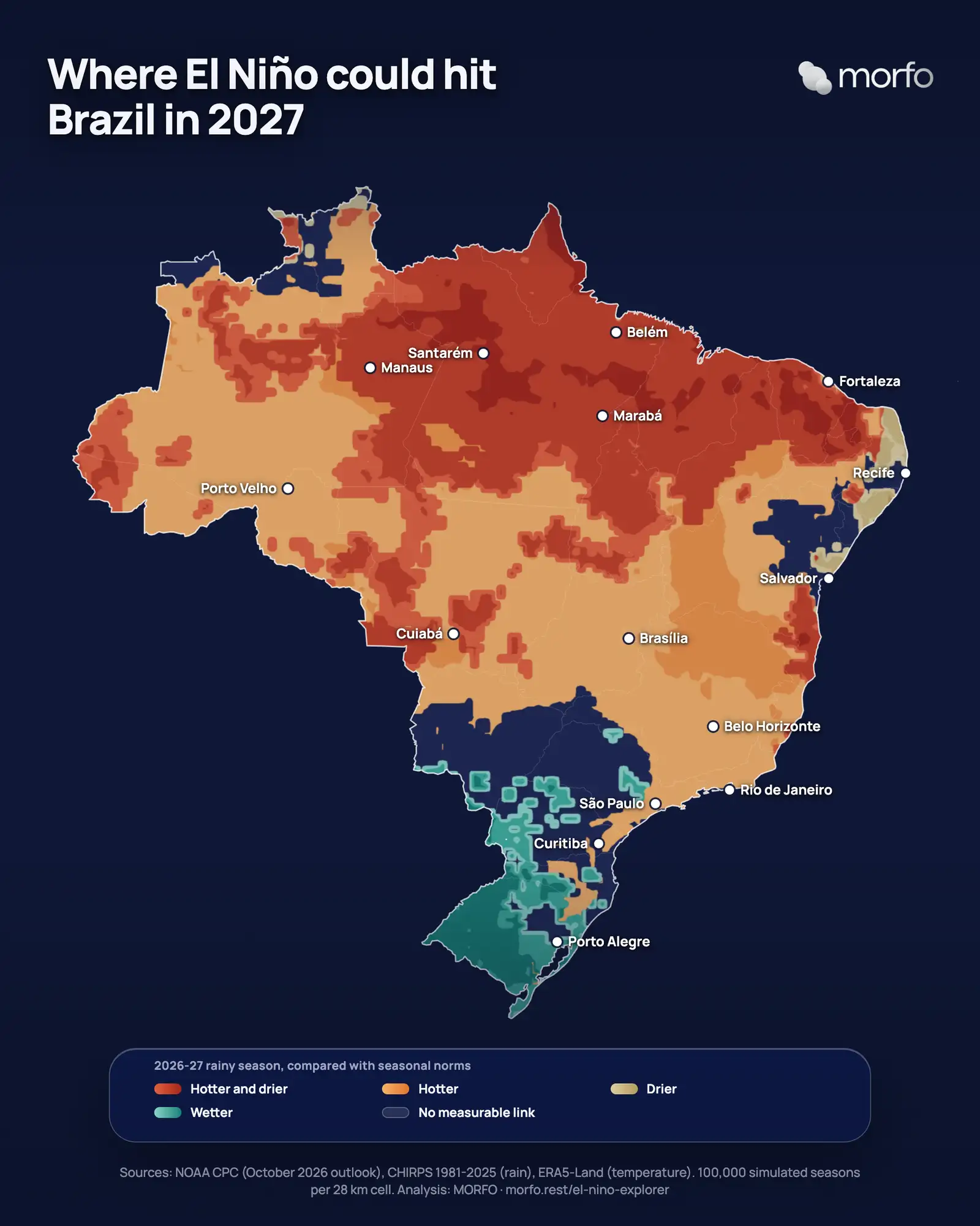
Crossing the two readings gives the full picture:
- 37% of Brazil is likely to be hotter and drier at the same time, in 1,111 municipalities. It is the hardest case for anyone planting, and it is concentrated in the North and the Northeast.
- 47% is likely to be hotter, with no measurable change in rain.
- 9% shows another effect: more or less rain without 0.5 °C of warming, or a lighter warming.
- 7% shows no measurable link with El Niño.
The regions will not live the same season. In the North, 55% of the region is likely to be hotter and drier. Where the effect is measurable, the Amazon region loses 16% of its rainy-season rain, about 237 mm, and gains 0.9 °C. In the Northeast, 47% of the region is likely to be hotter and drier, and the semi-arid interior loses 22% of its rain. In the central savannas, the loss is 15%, about 177 mm, with 0.8 °C more. In the far South, the sign flips: 97% of the southern grasslands lean wetter, with about 29% more rain.
Places, not averages
- Calçoene, Amapá: 36% less rain, about 780 mm, the equivalent of 54 days of a normal rainy season.
- Barra do Quaraí, Rio Grande do Sul: 52% more rain, 3,800 km away, in the same season.
- Curuá, Pará: the rains could settle about 74 days later than in a neutral year, and the useful planting window could shrink from about 154 days to 79.
- Marabá, Pará: in very strong El Niño years, an October planting received 32% less rain in its first three months, and a replanting in March and April faced a 36% drop.
Among planting regions, the longest delay in the start of the rains is in Ilhéus-Itabuna, in Bahia, with 43 days. Santarém follows with 41 days, and Altamira with 34.
How the analysis was built
Three sources feed the model: CHIRPS for rain (Climate Hazards Center, UC Santa Barbara), ERA5-Land for air temperature (ECMWF and Copernicus), and NOAA's ONI index, which classifies each season by the strength of El Niño. Each cell has 44 rainy seasons on record since 1981. Its rainy season is its five wettest months, centred on December to February. The 2026-27 season was then simulated 100,000 times per cell, drawing El Niño's strength from the probabilities NOAA published on 8 October.
What the analysis does not say:
- It describes regional scenarios, not a forecast for a given property or a given day. Each figure is the most likely value within a range.
- El Niño is not the only driver. The tropical Atlantic weighs heavily on the Northeast and the northern Amazon region, and it is not part of this calculation.
- It covers climate only, not crop yields, prices or fire risk.
- It uses NOAA's 8 October bulletin. The next one is due on 12 November.
What it changes for a planting decision
A seedling planted at the start of the rainy season lives on the rain of its first three months, before its roots reach deeper water. Higher temperatures raise the plant's water demand, and less rain cuts the supply. When the rains settle three weeks late, the seed order, the nursery schedule, the field teams and the contract all have to move with them, as described in our article on the cost of missing the planting window.
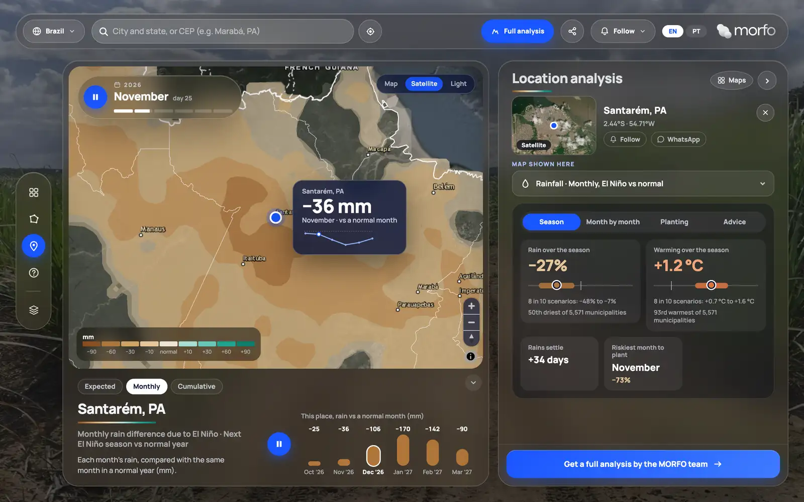
That is why the results are open in the El Niño Explorer, in Portuguese and English. Anyone can search a municipality and see, month by month, the temperature and rain to expect, how late the rains could start, and which planting month is the riskiest.
"A challenging season changes the way we plant. It does not change the decision to plant. What worries me is a team going out on the usual date and finding dry soil, with the heat already there." - Grégory Maitre, CEO, MORFO Brasil
The useful question this season is not whether El Niño will be strong. It is when the rains will settle on each plot, and whether the planting calendar is built from that date or from the contract.