Where a restoration project meets fewer restrictions
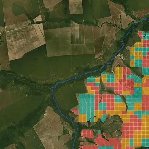
Where a restoration project meets fewer restrictions
- Pasture and cropland free of restrictions
- Cleared in the last 10 years (blocks a carbon project)
- Under IBAMA embargo (needs regularisation)
- Indigenous land, quilombo or strict protection area
- Standing native vegetation
What the map shows
Not all open land can host a restoration project with carbon credits. Indigenous lands, quilombos and strict protection areas cover 20.6% of Brazil and follow their own rules. Land cleared in the last 10 years and areas under IBAMA embargo are also left out, or need regularisation first. In the end, 28.7% of the country is open land without these restrictions. We made this map to show, before any site visit, where a project meets fewer restrictions.
How we built it
For each 5 km cell, we applied the first reason that holds: indigenous land, quilombo or strict protection (20.6% of Brazil); active IBAMA embargo (0.5%); native vegetation cleared in the last 10 years, now open land (2.6%); otherwise standing native vegetation, or pasture and cropland without restriction.
What the map does not say
- The 10-year rule applies to reforestation carbon projects. For restoration without credits, this land remains possible (31.3% of Brazil in that case).
- An embargo does not automatically make land ineligible: it is a legal and reputational risk, and it can be exactly where the law requires restoration.
- Indigenous lands and quilombos are not forbidden in principle: they require consent and specific governance.
- The 10-year rule is a simplified reading of the VM0047 methodology on MapBiomas classes.
How we use this data to analyse an area
On an area
Legal restrictions are one of the 21 criteria MORFO combines to assess an area, and they work as a filter. Indigenous land, protected areas, IBAMA embargoes and recent clearing can block a carbon project or require regularisation first. In the MORFO Ri pre-analysis, this check comes first, as a list of blockers with the status of each.
What MORFO does next
- Prescribes what to plant, at what density and with what soil preparation.
- Organises the seeds.
- Plants with our field partners.
- Measures the results over the years in MORFO Ri.
The data
MapBiomas collection 11, 2025; IBAMA embargoed areas (May 2026 extraction); FUNAI indigenous lands and INCRA quilombola territories (November 2026); CNUC/MMA strict protection units (July 2026). MORFO analysis. See the sources
MORFO scientific team · Version 1, updated November 2026
Related maps
How to cite
MORFO Data. Where a restoration project meets fewer restrictions. MORFO scientific team, version 1, November 12, 2026. Available at: https://www.morfo.rest/resources/data/carbon-restrictions
CC BY 4.0 licence: reproduce with this citation and a link to the page. Source data keep the licence of each source.
Want this analysis for your area?
- Send your areaLocation, polygon or CAR number.
- Talk with the teamTo understand the project.
- Pre-analysis of the areaBlockers, operable area, site score and first methods.
MORFO Restoration Intelligence is the platform where each area's pre-analysis, plan and follow-up come together. See MORFO Ri
Your area
LET'S GROW with MORFO